

Drone Photography and Videos for Agriculture
Skyhigh Visuals provides drone aerial photos and videos for agriculture in South Jersey, including farming, nurseries, forestry, crop monitoring, livestock tracking, irrigation insight, and reliable documentation that supports planning, record keeping, and agricultural management decisions.
A Clear View of South Jersey Agricultural Operations
Drone aerial photos and videos for South Jersey agriculture can show land, crops, livestock, and systems from a full-property perspective. My drones capture clean, detailed visuals that help make sense of how everything connects. From field layout to activity across the land, these visuals give a level of clarity that ground-level views just can't match.
Drone aerial photography and videography services for South Jersey agriculture help reduce guesswork. I focus on capturing images and video that show what's happening across the property in a way that's easy to review and use. Over time, these visuals build a strong record that supports planning and day-to-day decisions for all types of agricultural uses.
Agricultural Applications
Drone aerial photos and videos for South Jersey agriculture cover a wide mix of South Jersey agricultural operations, including farms, crops, livestock, nurseries, forests, and irrigation systems. Each project focuses on clear monitoring, mapping, and documentation that helps track conditions, identify issues, and support management across the entire operation.
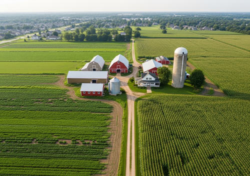
Farms
Drone aerial photos and videos for South Jersey farms can capture full-property aerial views that show how a farm is laid out and how different areas are being used. These visuals include field organization, access paths, and the placement of structures like barns and storage areas. They can also help track seasonal changes across the entire property. It becomes easier to see how land use shifts over time, identify unused areas, and document the overall condition of the property. Large-scale documentation like this gives a consistent visual record that can be referenced at any point.
Crops
Health Monitoring
Drone aerial photos and videos for South Jersey crops can identify areas where crops aren't performing as expected. This includes uneven growth, stress patterns, and sections that may be dealing with drainage issues. These aerial views make it easier to catch problems early, especially in larger fields where issues can go unnoticed from the ground. Major weather events can also be captured so changes can be reviewed and tracked.
Record Keeping
Drone aerial photos and videos for South Jersey crops can document planting stages, mid-season growth, and pre-harvest conditions. Over time, these records show how crops develop across a season and how different areas perform. They provide a reliable way to compare crops from one season to the next, they support internal tracking, and they help maintain a consistent history of crop conditions.
Mapping
I provide clear top-down views that outline field boundaries, crop rows, and layout patterns. These visuals help break fields into manageable sections and support planning decisions. Mapping your South Jersey crops with drone aerial photos and videos also helps with organizing planting strategies and adjusting layouts based on past performance.
Livestock
Drone aerial photos and videos for South Jersey livestock can capture feeding areas, shelter usage, and movement paths. These details help show how livestock interact with the land and where adjustments may be needed.
Herd Monitoring
Drone aerial photos and videos for South Jersey livestock can show where livestock are located and how they move across grazing areas. These visuals help track patterns and identify areas that may be overused.
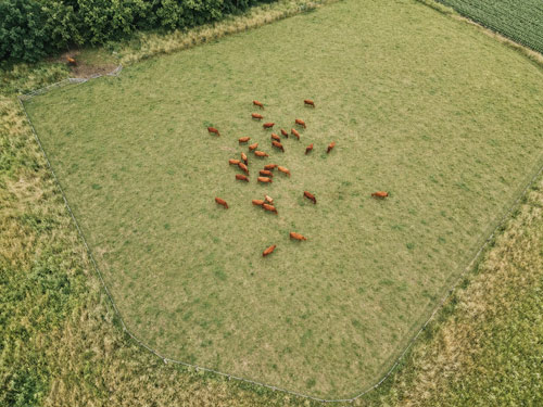
Locating Animals
Finding animals across large South Jersey properties can be time-consuming. Aerial views make it easier to locate livestock, even in areas with limited visibility. This reduces the time spent searching and helps keep better track of the herd.
Checking Fences
Fence lines can stretch across large areas, and walking them takes time. Drone aerial photos and videos for fences can scan those lines quickly and identify breaks, weak sections, or damage.
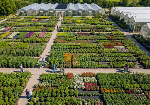
Plant Nurseries
Drone aerial photos and videos for South Jersey plant nurseries for agriculture provide a clear overhead view of nursery layouts. They capture how plants are grouped, how spacing is set up, and how inventory is arranged across the property. These visuals help track changes over time, identify areas that aren't being used efficiently, and support planning when adjustments are needed. It's a simple way to keep a consistent visual record of how the nursery is organized.
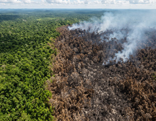
Forestry
Drone aerial photos and videos for South Jersey forests provide a reliable way to monitor wooded areas and keep track of changes over time. They can capture tree density, canopy coverage, and clearing progress. Storm damage, fallen trees, and access paths can all be reviewed from above. They can also help map areas that have been damaged by forest fires and show how damage is spread across wooded sections. These visuals are useful when planning cleanup and recovery efforts.
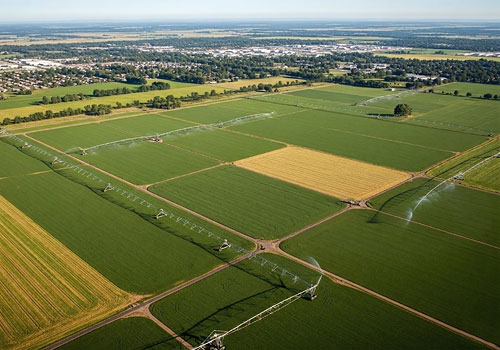
Irrigation
Aerial visuals support better planning of irrigation systems. Drone aerial photos and videos for South Jersey irrigation systems can capture the layout of fields so systems can be adjusted to match the shape and flow of the land. They can document coverage consistency, runoff patterns, and changes after system adjustments. This helps track how well irrigation is working across the property.
Patterns in soil color and crop condition can point to moisture imbalance. Drone aerial photos and videos for South Jersey irrigation systems help reveal these patterns across large areas. Oversaturated areas or unexpected pooling can point to leaks or system issues. Areas that aren't receiving enough water can also be captured; dry zones are easier to spot from an aerial view.
Contact Me for Drone Photography & Videos for South Jersey Agriculture
If you need drone aerial photos and videos for South Jersey agricultural monitoring and planning, contact Skyhigh Visuals to get started. Call me today at 609-760-0528, or email me,.
